Friday, June 29, 2018

Some areas reopen after flooding rains close parts of the Great Smoky Mountains NP

Use Caution folks.
Little River Road from Metcalf Bottoms Picnic Area to the Townsend Wye will remain closed due to down trees and rocks.
Elkmont Campground, Little River Road from Sugarlands Visitor Center to Metcalf Bottoms Picnic Area, Metcalf Bottoms Picnic Area, Upper Tremont Road, and Wear Cove Gap Road have all been opened.

Wednesday, overnight, the park received heavy rain at high elevations across the park including 2.54 inches of rain recorded at Clingmans Dome. Over a 6-hour period, Little River rose approximately 6 feet above the normal level at the Townsend Wye. The park continues to monitor flood waters across the park.
Stream crossings at lower elevations may have already, or will become more challenging and thus dangerous as the water flows down the mountains. Be smart and do not be to proud to turn around.

For more information on road closures, please follow SmokiesRoadsNPS on Twitter.

--NPS--


Tuesday, June 26, 2018

Blooms and Bears in the Smokies

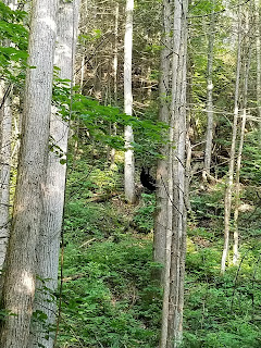
These are some of the annually gorgeous blooms I've been able to see this spring and early summer. The bear I saw earlier this month.


Thursday, June 21, 2018

Rabbit Creek Trail

The Rabbit Creek Trail is accessible at the west end of the park near the Abrams Creek camping area.
The trail begins with a wide stream crossing where you'll have to remove your footwear because the bridge is still out from flooding a couple of years ago.
I'd recommend you not lace up your boots until after you cross Abram's Creek; using caution and a hiking stick or pole as you cross.


There are a couple of places being used for the crossing, however one is all torn up and muddy from horses and their passengers, while the other presents a challenge in safely getting from the rugged steep shore into the water.
This trail would be considered moderately difficult for the avid hiker. However if your hiking experience is limited or you're not used to extended inclines in your hikes it would be considered more on the difficult side of that.
We hiked into campsite #15, and returned which is approximately 7mls+. This trail provides access to some areas of the park which are traveled less and awesome routes for backpacking overnight.
David took these photo's on the hike June10th, 2018.

Old Sugarlands Trail

While my friend David was over from Nashville he had the opportunity to stay busy hiking and enjoy some new routes for him in the Smokies which included the Old Sugarlands trail, and a portion of the Rabbit Creek trail.
The Old Sugarlands trail is a moderately difficult walk, accessible from the parking lot at the Sugarlands Visitor Center (SVC), or a small parking area just up the road towards Gatlinburg from SVC.
David reported with delight his experience on this trail with the blooming plants, the remnants of the old cabin along the route and his first time for "working with" a bear on his own. I say "working with", in describing his reaction to the two cubs he encountered along his hike in this trail.
He stopped, identified himself to give the bears a further heads up, increased his distance by backing up slowly and began looking for momma bear, who he quickly spotted on the ridge. And if I remember correctly he told me that the cubs ran in opposite directions, up trees and the mother bear (That's her in this photo he took), vocalized her presence and kept an eye on him. As the initial surprise for everyone faded "Deep Dave" continued to "talk" to the bears as he made his way down the trail.
This hike Dave took was on June 9th, 2018.

Hiking in the Great Smoky Mountains National Park (GSMNP) 2018

Dudes! and Dudettes!, Over the past month the Rhododendron's have begun to bloom in full, the flame Azalea's have pretty much come and gone, though I saw some still scattered along a trail I hiked yesterday, and the busy season for the GSMNP has begun.
Wow, it's pretty dry at my house in the foothills right now. 
Though there has been scattered rains throughout the region over the last few weeks my immediate area has been missed, and regionally, with that lack of consistent rain some of the backcountry watering holes may be dropping.
 So plan your hike with alternative routes and destinations in case there is an unexpected crowd of people, a trail closure or weather event you have to make adjustments for to find some peace. Remember to hydrate! Drink water.
Sodas and other caffeine based drinks are not good for this purpose. They are diuretics and thus tend to remove fluids and other things our bodies need when exerting ourselves in hot humid weather.
For the most current information in the Smokies check the twitter account at https://twitter.com/gsmnp, or call the Sugarland's Visitor Center at 865-436-1297.
My friend Dave, from Nashville took this photo OTG from a trail we hiked a couple of weeks ago and those pics in the following post describing some other trails we hiked on his visit.