Thursday, April 29, 2010
Practice Appreciation
As the walk began, before I left the parking lot I heard children in the woods on a trail I was considering for a short 2ml loop so I decided to start the loop from another direction. About 100 yards along the trail were two ladies sitting and talking and I thought they chose a great spot and day to do this. Sitting in the shade with the Middle Prong sounding busy across the road. Turns out they were there to ensure that none of the kids went beyond them on this trail as the kids were learning how to use a compass.
Along my walk I could here someones domestic dog barking up on the West Prong trail and I wanted to scream!! For those readers who have a dog and come to the GSMNP, your Dog is NOT ALLOWED on trails. See The Sign at the beginning of Every trail?
This is a safety issue and a Federal regulation.
Twenty or so minutes later as I approached the West Prong trail from the loop I heard very close by, a large animal moving through the thickening underbrush and I hoped it was not pissed because of the dog or scared enough to act a fool! Whatever it was.
These local, state, and federal parks do not belong to me they belong to us and so I should be considerate of other folk's safety and how my behavior affects another's day in the woods. Be it practicing "Leave No Trace" camping and hiking or reading about the parks policies before I bring my ass to this place. Uuuugh!
I tried to create good out of this learning opportunity and think I just succeeded. Peace
Tuesday, April 27, 2010
Blooms and Snow Along West Prong
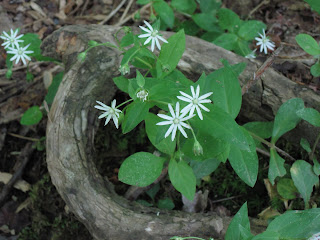
Wow, what a great day to spend part of in the mountains! The blooms along this trail are just increasing with more Flame Azalea, Trillium, and various other flowers and colors! Here are few that are new along this route to me anyway.
As I almost reached my halfway point, 3 mls, a frozen precipitation began to fall on me and it did not appear to be hail but rather sleet or a heavy wet snow. This was above 3000', late in the afternoon, and in the Smokey Mountains. I experienced this frozen moisture for a few minutes on top of Rich Mtn. and again briefly as I began my descent from campsite #5. Days like this are when I'm glad I was a Cub Scout and my brothers were Boy Scouts so I learned to "be prepared" because I had grabbed some work gloves out of my trunk and put on a jacket as I prepared to start the hike.
The jacket tucked under my shoulder strap of my bag and the gloves went in the jacket pockets when not in use. Though both items became very useful several times along this 6 ml. walk.
From what little I know about specific wildflowers I can say this with confidence and that is there will be blooms of various sorts along the West Prong for several weeks. Peace
Sunday, April 25, 2010
West Prong Blooms
This afternoon was a wonderful time for walking! As I made my way about a mile into this walk I was overcome with a flood aromas from blooms, new plants and moist soil from yesterdays rain. The flavors that arrested my sense of smell were powerful and caught my attention more than once along this 4.5 ml hike. I guess you'll have to see for yourself if you're in the area in the next few weeks.
A strong wind was diminished by the terrain making it a cooling pleasant breeze full of spring smells on the trail. With it's smooth sound through the trees the wind was also very soothing as my eyes noted the varying shadows and contrast in each view along the route.
The Crested Dwarf Iris was still prominent in places with numerous other blooms occurring or on the verge of doing so. I saw the back end of a bear as it tried to remain unseen by quickly dashing into some cover about a mile out of #18 on my return trip. What a wonderful day!
Friday, April 23, 2010
Blooms and Bears
Todays afternoon walk which took me up the Rich Mtn. trail on a great day to be appreciating the wild life was altered just before the half way point. This mother and cub were on the trail just before the final turn bringing you to campsight #5. They didn't move except the cub started up the tree beside them a few times only to come back down after climbing up a few feet.
I saw only blooms and these bears along the trail. Peace
Wednesday, April 21, 2010
Enjoy Greenways? Prefer Clean Drinking Water?
Tuesday, April 20, 2010
Blooms Along The Trail
Blooms along Chestnut Top trail that is and mostly along the first two or three hundred yards up from the Townsend 'Y'. It was a great day with light rain and a late afternoon start I saw only two folks as they were making the final descent back to their vehicle.
This being the case the trail was quiet except for raindrops and my occasional laughter from the joy I felt walking in the rain over the next 2 hours. With the flatness of sound from the steady rain and my breathing times like this are exceptional opportunities to utilize ones visual awareness and practice looking off the trail frequently and into the trees for wildlife.
This is a practice to which I attribute a large part of the visuals I have put on bears and other animals. If I am staring at my feet for 5 miles I'm wasting opportunity's to see the lizard on the log or the bear quietly moving off the trail to avoid being seen. Saw neither today...seems they had a enough sense. The trail is currently loaded with various wild blooms here are a few. Peace
From Park Headquarters
“Reward Yourself – Hike the Smokies Challenge” Launches
on Sunday, April 25, 2010
Do you need a little motivation to get out and enjoy the great outdoors? A new program, “Reward Yourself - Hike the Smokies Challenge” in 2010, in Great Smoky Mountains National Park will help visitors reach individual milestones. The Park is distributing mileage record books for free on Sunday, April 25, at Sugarlands and Oconaluftee Visitor Centers between 10:00 a.m. and 4:00 p.m. and at the Cades Cove Visitor Center from 1:00 p.m. to 5:00 p.m. After April 25, the pocket-size booklets will be available at the three visitor centers for $1.00.
The challenge is to keep track and record the mileage from each trail excursion, even if it is the same trail day after day. As a recreational benefit, when a person has “hiked” 100 miles, 250 miles, and 500 miles, he/she can bring their mileage record to one of the three visitor centers to receive a mileage pin and be recorded in the “Hike the Smokies” 2010 web records.
A video podcast, Day Hiking in the Smokies: Expect the Unexpected will also be launched on April 25th at:
http://thegreatsmokymountains.org/hike_smokies_challenge. This 3-minute video podcast will help visitors prepare for the weather extremes that can be found in the Smokies during a day hike. Two additional video podcasts are being developed in this series for release this summer and fall that will provide additional tips on hiking safety in the Smokies.
“Day hiking in the Smokies is a good way to get exercise while also discovering the beauty of this area,” said Park Superintendent Dale Ditmanson. He continued, “With over 800 miles of scenic trails to choose from, the possibilities for day hikes are endless.”
Well Heck! I need to get me one of them mileage keepin' books.
Friday, April 16, 2010
Spring Flowers Along The Way!
These Crested Dwarf Iris' were seen along the ______ _____ trail, just up from _____ beside _____, but somewhere near the West Prong trail. Mark and I did a a short loop late this afternoon and were allowed the pleasure of these beautiful plants along the way. White Trillium was not frequent on the trail though we saw a few on the last half of our walk. I look forward for more colors and varieties
Last Sunday's Walk With Friends
A beautiful day 4/11/10, on the West Prong trail for my friends to start their season of hiking. Well except for of the common pains seasonal hikers get after a layoff and first using some muscles to these levels again. Pat, Donna, and Mark all enjoyed the walk and the challenges it posed over the 4.6 ml RT to #18, where we sat along side the stream in a shaded area and enjoyed lunch. Aaaah! The Trillium looked eager to bloom as did the Some other flowers which turned out to be the Crested Dwarf Iris.
Monday, April 12, 2010
The Dragon....
Tennessee and North Carolina Cooperative Efforts Will Open "The Dragon"
KNOXVILLE, Tenn. - The Tennessee Department of Transportation will reopen an 11-mile stretch of U.S. 129/SR115 in Blount County known as "The Dragon" on Monday, April 12 at 8:00 a.m. The stretch of U.S. 129 from the Tabcat Bridge to the North Carolina state line will be open to traffic each day between 8:00 a.m. and 8:00 p.m. The section of U.S. 129 from just past the Foothills Parkway to the Tabcat Bridge will remain closed as crews work to remove a rockslide that closed the roadway in March.
The Tennessee Highway Patrol will provide traffic enforcement and Graham County, North Carolina will provide emergency response along the open section of U.S. 129 during daylight hours. Motorists are advised that emergency response will be limited in the area. Law enforcement will have zero tolerance for traffic law violations and will diligently enforce the area. U.S. 129 will be closed to traffic at the North Carolina state line at 8:00 p.m. each night until 8:00 a.m. the next day. The roadway will remain closed to commercial traffic and large RVs.
May the Force provide you with good judgement and the wisdom to follow it.
Saturday, April 10, 2010
Friday Afternoon on Rich Mountain
Hello! This day hike began at the Rich Mtn. trail head off of Rich Mtn. road, which is still closed for the Cades Cove work expected to wrap-up on the 24th of this month, April. The weather was wonderful as it actually cooled in the last few days. So with temperatures in the 60's up here and skies PC, and a nice breeze I enjoyed an undisturbed walk for approximately 5 mls. roundtrip. The route today took me to Cerulean Knob where I got this photo of LeConte I believe.
I've taken pictures of this peak before and figured it was either Clingmans or LeConte, and assuming what I saw on another web site is correct, and reviewing the pictures I'd say LeConte. (http://solitarywalker.com/rich_mtn_loop.htm)
Along the walk I noticed streams in places I'd never seen or heard them despite being 3 inches below average for the calendar year in these parts. As Meg the Hiker noted in her last entry with temperatures above the norm; 20 degrees plus on some days, earlier this week and last, this has cut short the time of some early blooms. However this Bloodroot looks great!
Wednesday, April 7, 2010
Easter in the Great Smoky Mountains/April 3rd and 4th
Day #1: Hiking Ace Gap Trail off of Rich Mtn. west of the better portion of GSMNP, the trail begins with a slight incline as we amble 5.8 miles mid/late afternoon, passing mountain homes scattered along the park boundary, deciduous trees yet to bud. I am incredibly psyched to be hefting at least 20 light lbs. of overnight gear. Cloud cover shifts and shades the trail, strong winds blow through the bare treetops. Will it rain? No hats, no coats, wearing shorts…the temperature is better-suited for late May, but raingear is packed (always!). Once reaching intersection of Ace Gap and Beard Cane Trail, we descend between high soft ridges, fallen leaves gold on the ground as the sun breaks through. This long hollow becomes a creek bed, remains so with mysterious forks of water forming and combining, currents changing direction out of sight. Rhododendron and white pine provide green color along the walk. Not much later, trillium buds rise from the ground but stand tight and unbloomed. Described as “marshy” by a friend, I can imagine in a rainy season, when foliage is full, this walk would probably be a lot wetter and muddier, perhaps cooler. Pit-stop at #3 for afternoon coffee and gathering water is delightful. Nice and clean with lots of flat space. I put on waterproof socks AFTER a major spill prior to arriving at campsite, not a bad tactic, but almost forget my Smartwool and liner socks drying on a tree branch. The abundance of small stream crossings, as well as blowdowns, make the 2.0 (approx) to #11 tricky, nonetheless a peaceful early evening. Shared #11 with a young couple from Louisiana who are out on a multiple-night excursion; they’d been fishing near Abrams Creek earlier, good company. Fatigue and hunger after 8.8 miles make setting up camp a slightly woozy experience, but once the fire is set and food cooked, I find a perfect lounging spot against a tree, quite snug on a fat root. Stars shine all night, moon settles on the tent not much before dawn.
Day #2: Easter Sunday in the Smokies, what a treat! Slow moving out of camp, the sun filters down, temperatures still agreeable. Much more uphill hiking today (“real hiking”--ha!) climbing up and over gaps, around shady brooks and bends, to Hatcher Mtn. Trail which is fairly strenuous but glorious, high views transmuting into a smooth riverbed walk, meeting Little Bottoms Trail. Wildflowers are clearly opening here, different varieties from yesterday, some seemingly shocked by the heat. At #17, a father and two small children are playing on a grassy spot beneath large trees. I say, “Looking for the Easter Bunny?” and Dad remarks they’d rather be here instead of church. No kidding! Upon reaching Abrams Creek Campground, activities are calm for a holiday weekend in GSMNP. I nap on a sunny picnic bench while partner goes another 0.5 to find our ride, generously offered. The wonderful variety of trail and landscape changes, my first overnight hike of the season (2010) has me feeling enthusiastic and seriously considering round-trip from Cades Cove to Hannah Mtn. Trail, back around to Gregory Bald for return, sometime soon.
Labels:
#11,
#17,
#3,
Ace Gap,
Beard Cane,
Hannah Mtn.,
Hatcher Mtn.,
Little Bottoms trail,
rodo's,
Trillium,
white pine
Sunday, April 4, 2010
Who's Behind Those Foster Grants?
That is Maria behind those cool shades and sporting the flip flops and socks! Her friend Sarah is sitting out of the picture which was taken just across the stream at Little Bottoms trail head at campsite #1. They were completing an overnight trip I'm thinking from #17, on Abram's Creek. We had come up on them as we made the final descent on the steep trail into campsite #1, and I admired the fact that she didn't bust it in the flip flops coming down the last ridge. Maria was proud and told us how she had assured Sarah she'd be all right hiking in them because "I'm a southern girl", and she made it! She told us she had to remove her boots because they were too small, told us she hadn't worn 'em in a while before beginning this trip. We hope they get out and appreciate the wild life more often and I congratulate them for getting out and enjoying the fabulous weekend in the Smokies!
Labels:
#1,
#17,
abrams creek,
foster grants,
Little Bottoms
Friday, April 2, 2010
Some Spring Pictures
Thursday, April 1, 2010
This Just in...yesterday, Cades Cove Schedule
The folks at the GSMNP Superintendents office sent this out March 31st, letting folks know...
that the popular Cades Cove Loop is expected to reopen Saturday, April 24,
about a month earlier than had been projected.
The Superintendent credits capable management and aggressive efforts by the contractor and the cooperation of the Federal Highway Administration, in conjunction with financial incentives built into the contract for the early completion.
In recognition of the completion of this long-overdue project and of National Park Week, the Park is planning two celebratory events. A Field Day has been set for Saturday, April 24 when only bicycles and pedestrians will be permitted on the road until noon. On Sunday morning, April 25 the Park and the Friends of the Smokies are planning a one-time-only “Cades Cove Loop Lope”, which will offer pre-registered runners a choice of the full 11 mile loop or a 3.5 mile loop course. Both events are being planned to minimize visitor inconvenience.
The weekend’s activities also coincide with National Park Week, a nation-wide celebration in National Park areas when visitors are encouraged to get out and enjoy the great American outdoors.
The Park has traditionally limited the Loop Road to bicycles and pedestrians until 10a.m. each Saturday and Wednesday from early May through September, but they have extended this one “bicycle closure” until noon to accommodate an anticipated greater number of people.
They are also expanding the parking area available to Loop visitors through use of one of the mowed pastures, and will be limiting access to the Cove beyond the
Townsend Wye to those coming to bike or walk until noon on Saturday the 24th of April. Thanks for y'alls hard work! Peace
Subscribe to:
Posts (Atom)